
What’s not to love about the Great British countryside?
Jam packed with ancient woodlands, dramatic peaks, glistening lakes, rolling pastures and much more, we’re incredibly fortunate to have easy access to all this natural wonder thanks to the interconnected hive of walking trails weaving throughout the landscape.
Having ventured along an innumerable amount of these walking routes over the years, there are certainly a handful which stand out to me as the cat’s pajamas.
Whittling down the list to 12 of my most favourite routes, step out on any of these trails and I guarantee you’re in for a brilliantly British ramble.
Keep your eyes peeled since I’ve even thrown some hidden gems in there for good measure!
Interested? Let’s get to it 👇👇
Best British Walks
Yorkshire 3 Peaks
Start point: Horton-In-Ribblesdale Car Park, Settle, North Yorkshire, BD24 0HE
Distance: 25 miles (40 kilometres)
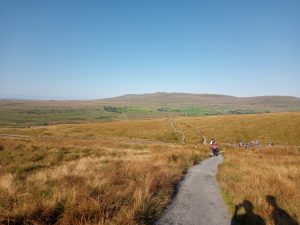
Starting with one of Britain’s most iconic National Parks, you won’t find much finer walking than in the famed Yorskhire Dales.
Jaw-dropping scenery, unspoilt countryside, a rich heritage & home to all sorts of wildlife, thousands of keen ramblers arrive here every year to tackle the Yorkshire 3 Peaks.
A hefty circular loop which guides you over the three mountains of Whernside, Pen-y-ghent & Ingleborough, the landscape vistas you enjoy from each summit are simply astounding.
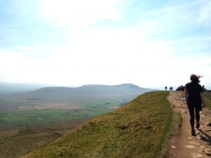
While some daring hikers decide to tackle all three peaks in one day as part of the Yorkshire Three Peaks Challenge, these crags are equally enjoyed as individual ventures, with many ramblers opting to tackle the trail over multiple days at a leisurely pace.
With plenty of other nearby points of interest surrounding each peak, two additional spots I’d recommend checking out during your visit would be Ingleborough Cave & the Ribblehead Viaduct.
In total, the walk comes in at roughly 25 miles and can be started from various different points. Our chosen point has always been from Horton-in-Ribblesdale due to having plenty of spots to park and a few good pubs to refuel afterwards!
Click here for our ‘How To Train For The Yorkshire 3 Peaks Training Plan 👈
Lizard’s Point to Kynance Cove
Start point: Lizard Point Car Park, Landewednack, Helston TR12 7NT
Distance: 4.9 miles (8 kilometres)
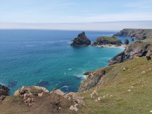
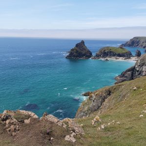
Moving much further South to the sandy beaches & lush blue waters of Cornwall, the coastal trek from Lizard Point to Kyance Cove is an absolute belter of a walk for those who’d like to enjoy some of Britain’s finest coastal panoramas.
A gentle 8-kilometre seaside ramble, you’ll stroll along one of the most spectacular stretches of Cornish coastline and get the opportunity to snap a pic together at the southernmost point of mainland Britain. Proper bucket list tackle!
Once completing the serene hike from Lizard’s Point you’ll arrive at Kynance Cove, a picturesque & craggy beach which has been a hotspot since Victorian times.
A popular spot for beaching & picnicking, if the swell is just right you’ll also likely be able to watch the surfers in action too!
Pendle Hill (Forest of Bowland)
Starting point: Barley Picnic Site, Barley, Lancashire, BB12 9JX
Distance: 5 miles (8 kilometres)
As a Lancashire lad born and bred; I’m incredibly fortunate to have the Forest of Bowland right on my doorstep.
Having spent many a weekend as a wee lad exploring the vast trails on offer in this fabulous region, some of my all-time favourite walks here include the Gisburn Forest Waterfall Walk and Pendle Hill.

Standing at a striking 557 metres (1,827 feet) above sea level, Pendle Hill dominates the surrounding landscape for miles and miles – falling only 53 metres short from being classified as a mountain.
Inspiring people from all walks of life over the years (including Tolkien, author of Lord of the Rings), Pendle Hill also attracts history buffs, supernatural fanatics and even ghost hunters – most notably the Most Haunted TV crew who visited Pendle Hill for a live investigation back in 2004.
This is because the large and imposing fell is synonymous with Pendle Witch Trails of 1612; perhaps the most well known and well documented in all of English history.
With numerous walks up to the summit of the dramatic Lancashire fell, I’ve always found starting from Barley to be the most enjoyable and most convenient.

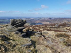
Bleaklow Bomber Crash Site
Starting point: Glossop, Peak District, SK13 7PQ
Distance: 4 miles (6.4 kilometres)
While the Peak District is full of scenic splendour, few folks know it’s also home to perhaps the UK’s most chilling historical site.
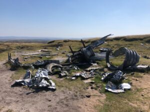
Tragically crashing here during a routine flight in 1948, much of the wreckage still remains scattered on the hillside today along with a touching memorial plaque for those who lost their lives.
With several ways to reach the site on foot, our preferred route has always been via the Snake Pass trail, which can be started from the A57 main road that runs between Ladybower Reservoir & Glossop.

Once arriving at the site, you can pay your respects before heading back the same way, or instead continue on to admire the belting views from on top of the nearby ‘shelf stones’.
Click here for the Ultimate Bleaklow Bomber Walk Guide 👈
Glencoe Lochan (and Harry Potter Hagrid’s Hut)
Starting point: Glencoe Lochan, Ballachulish PH49 4HT
Distance: 1 mile (1.6 kilometres)
The Scottish Highlands truly is a walker’s paradise.
Home to Fort William (the outdoor capital of the UK) and amass with popular hikes such as Ben Nevis and the West Highland Way, there are also plenty of hidden gems in the area which deserve plenty more praise.
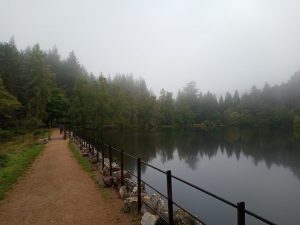
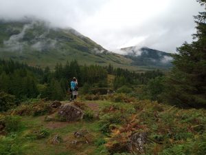
One of the finest examples of this is Glencoe Lochan. Nestled within Lochaber Geopark, Glencoe Lochan is found between the sparkling waters of Loch Leven and the jaw-dropping Glen Coe mountain range and looks like it’s been pulled straight out of a fairytale.
Often overshadowed by other popular hiking spots, the small loch remains unspoilt and delightfully tranquil, providing several well-laid out trails which are suitable for pretty much all walking abilities.
Coming in at just 1-mile in length, for those wanting to extend their ramble further, you can always stroll 30-minutes down the road and explore the exact spot where they filmed Hagrid’s Hut in Harry Potter!
While the hut sadly no longer remains at the location, this secluded spot is well worth the trip for the beautifully atmospheric vistas alone.
Click here for all you need to know around Harry Potter’s Hagrid Hut 👈
Snowdon (via Watkins Path)
Starting point: Near Pont Bethania, Caernarfon, LL55 4NQ
Distance: 8 miles (13 kilometres)

Without question, Snowdon is one of the finest peaks in the whole of Britain.
Sitting at the heart of Snowdonia National Park, there are upwards of eight different trails winding to the summit, all providing different perspectives from which to admire the jaw-dropping Welsh landscape.
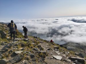
While the Llanberis Path is the most popular and recommended route up Snowdon for hill climbing newbies, my personal favourite way to the peak has always been via the Watkin Path.
A tough but rewarding incline with a white-knuckle scramble section that’s sure to have your knees quaking, few hikers know that this route is also home to an incredibly gorgeous hidden waterfall.
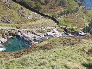
While you don’t have to hike all of the Watkins Path to enjoy the waterfall plunge pools however, I’d still definitely recommend conquering Snowdon via this route if you’re up to the task.
The views along the way are simply astounding and trust me, jumping in the those crystal clear gorges feels all the more rewarding on your way back down from the summit!
Click here for the Ultimate Watkin Path Snowdon Guide 👈
Malham Cove Circular Trail
Starting point: Chapel Gate, Malham BD23 4DA
Distance: 4.5 miles (7.2 km)
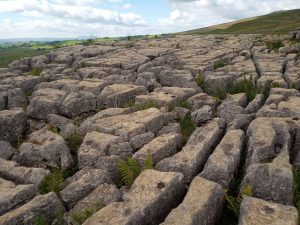
A gigantic & curved limestone cliff-face looming just half a mile north from the quaint village of Malham, Malham Cove stands at an imposing 260 feet and has wowed & inspired keen admirers for centuries.
Surging in popularity ever since the iconic limestone pavement sitting atop of the Cove was used as a filming location for Harry Potter in 2010, this hotspot is best hiked to via the Malham Cove Circular Trail.
Coming in at 4.5 miles in length, the Malham Cove Circular Trail guides you through the sublime Yorkshire Dales countryside and passes by several other extraordinary nearby geological formations before finally arriving at Malham Cove’s unique limestone pathway.
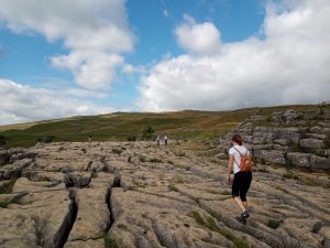
Spanning roughly 300 metres wide, acidic rainwater has gradually weathered out the characteristic cracks and gaps in the limestone through the years, giving the cove it’s characteristic pavement-like appearance.
Potter heads can clamber around the rocks & try to find the exact spot where the Harry Potter scene was filmed. Even if you aren’t a fan of wizards however, I’m positive you’ll appreciate the tremendous views of the Yorkshire Dales landscape from above
Click here for the Ultimate Malham Cove Walk Guide 👈
Buttermere Lake Walk
Starting point: Lake District National Park, Buttermere, CA13 9UZ
Distance: 4.5 miles (7 kilometres)
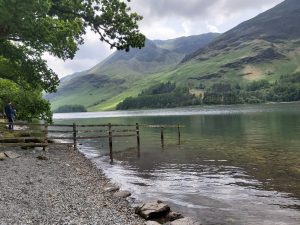
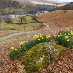
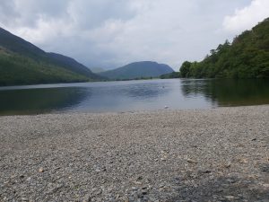
If you’re a fan of lake walks, then you need look no further than Buttermere Lake.
Fairy-tale like in appearance and nestled within quintessential Lake District countryside, this gentle 7-kilometre stroll takes you around the sparkling body of freshwater before finishing back at Buttermere; one of most idyllic villages in the whole of Lakeland.
Suitable for walkers of all abilities, along the way you’ll also have the chance to venture off the standard loop and discover the stunning nearby locations of Sour Milk Gyhll Waterfall and Crummock Water; one of the most gorgeous open water swimming spots in the National Park.
Furthermore, there really is no better way to finish a proper British walk than with some proper British pub grub! Why not head to the Bridge Inn in the heart of town to top off you adventure with some a nice meal and an ale (or two)!
Click here for the Ultimate Buttermere Lake Guide 👈
Trinnacle Trail
Starting point: Binn Green Car Park (RSPB), Oldham OL3 7NN
Distance: 4.5 miles (7.2 kilometres)
Hiding somewhere on the hillsides of Saddleworth Moor stands The Trinnacle, a uniquely shaped gritstone pillar which has seen a surge in popularity as of late.
A quick glance at some images of the dramatic rock formation and its not hard to see why…

Providing unrivalled panoramas of the surrounding landscape and reservoirs below, some daring hikers even choose to clamber on top of the three-pronged pillar which can make for some rather dramatic pictures!
Best found along a route dubbed ‘The Trinnacle Trail’, you’ll also find plenty more interest along the way. Comprising of three dazzling reservoirs, waterfall scrambles, steep hillsides paths and eye-catching scenery throughout; it’d be criminal if this route didn’t make the list!
Click here for the Ultimate Trinnacle Trail Guide 👈
Lumb Hole Falls Circular Trail
Starting point: Hebden Bridge, HX7 6JE
Distance: 9 miles (15 kilometres)
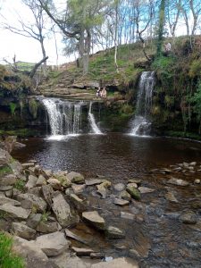
A hidden waterfall nestled in the stunning wooded Pennine valley of Hardcastle Crags, for years Lumb Hole Falls has served as a secluded paradise for those in the know.
Also nicknamed the ‘Hebden Bridge Waterfall’, Lumb Falls is often used as a picnic & wild swimming spot – when the water is deep enough you can even jump in straight from up top!
While it is possible to simply drive & park up near the waterfall, I’ve always felt this location is better seen as part of the Lumb Hole Falls Circular Trail, a 9-mile ramble which can be started from the quaint town of Hebden Bridge.
With plenty to discover, this scenic ramble first guides you through the enchanted woodlands of Hardcastle Crags before venturing over the surrounding rolling moorlands. Providing belting views of proper Yorkshire countryside, in the distance you can even spot the iconic Stoodley Pike monument (another great walking spot!)
Once you descend from the hillsides back into the woodland where Lumb Falls is located, keep your eyes peeled for the ‘Six Young Men’ plaque by the water – a moving poem which was inspired by a family photograph taken in the valley of six recruits who all tragically died during the First World War.
Click here for our detailed Lumb Hole Falls Walk guide 👈
Kinder Scout via Jacob’s Ladder
Starting point: The Old Nags Head, Edale, Hope Valley, Derbyshire, S33 7ZD
Distance: 8.7 miles (14 kilometres)
Laying claim to the highest point in the Peak District at 636 metres, Kinder Scout is a peak which should be on every hillwalker’s bucket list.
Not least because of the exhilarating climb and awe-inspiring scenery, but also for its monumental historical significance.
Unknown to many visitors walking up the craggy peak, this location was home to the notorious Kinder Scout Mass Tresspass of 1932.
As so many of us take the right to roam in the Great Outdoors for granted these days, just less than 100 years ago this wasn’t always the case.
With many rich landowners hogging the countryside and closing it off to the public, 400 rebellious walkers decided to illegally make their way onto Kinder Scout in direct opposition. Commotion ensued and a total of 5 people were arrested.
Despite the harsh sentences imposed upon the leaders, this Trespass sparked a wave of public sympathy and proved to be a catalyst in eventually securing the right to roam that we all enjoy today.
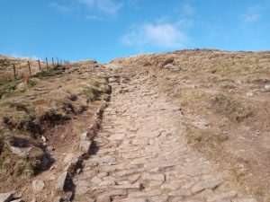
With numerous fantastic routes to reach the summit, one of my favourites has always been via Jacob’s Ladder from Edale.
Taking around 2 hours from the heart of the town to reach the summit at Edale Rocks, the arduous incline up Jacob’s Ladder is bound to get those legs burning, though the epic views you’ll enjoy from high above are more than worth it!
Click here for the Ultimate Kinder Scout via Jacob’s Ladder Guide 👈
Rydal Cave
Starting point: White Moss Carpark, Ambleside, LA22 9SE
Distance: 2 miles (3.2 kilometres)
Topping off our list with another Lake District classic, Rydal Caves is surely one of the most photogenic caverns in the whole of the UK.
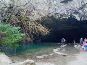
Long disused and open to the public, the cavern has grown even more in popularity after it was used as a pivotal filming location for Netflix’s medieval fantasy ‘The Witcher’.
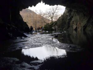
With the trail to-and-from Rydal Cave coming in at only around 2 miles in length, the stroll is a gentle one and offers the perfect vantage point to admire the Lake District’s picture-perfect scenery. Once arriving at the cave, be sure to carefully navigate the stepping stones and even take a peep inside!
Once admiring Rydal Caves, you can simply head back down along the same footpath you came, although we’d certainly recommend popping down to also check out Rydal Water before returning to the car.
If you’re feeling particularly adventurous, there are numerous trails available to extend your ramble after visiting the cavern, including a picturesque footpath taking you all the way to Grasmere; a quaint village that’s home to the most irresistible gingerbread on the planet. The perfect post-hike treat!
Click here for our Ultimate Rydal Cave Walk Guide 👈
More Resources
For more walking guides, tips, tricks & outdoor adventures, be sure to stick around and explore more of The Walking Northerners site – there’s bound to be something that’ll peak your interest!
Happy walking 🚶🚶