
Gwydir Forest Park lies in the heart of Snowdonia and encircles the village of Betws-y-Coed – largely touted as one of the National Park’s most picturesque villages.
A favourite among ramblers and mountain bikers alike, the forestry is home to numerous trails all varying in distance & difficulty, meaning there’s a trail here suitable for pretty much anyone & everyone.
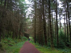
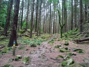
As you venture through the craggy landscape of Gwydir Forest Park, you’ll have the chance to explore ancient woodlands, steep hillside trails, serene lakeside views, gentle boardwalk strolls, old miners’ paths and much more.
Likewise, after finishing your excursion here you can always replenish those energy levels at one of the cracking inns or eateries in Betws-y-Coed.
Interested in taking a walk here for yourself? Then let’s get to it 👇
About Gwydir Forest Park
Sometimes spelt Gwydyr, Gwydir Forest Park derives its name from the ancient Gwydir Estate – established by the John Wynn family of Gwydir Castle – who once upon a time owned the whole area.
Interestingly, a chunk of the forest has been designated a Site of Special Scientific Interest (SSSI). This is because the area is host to a rare family of plants known as metallophytes, which are only found around old metal workings.
The area was once a mining hotspot and the forest is still scattered with the remnants of many former metal mines, and below the surface lies a maze of tunnels which are said to run miles in length!
Rife conditions for metallophytes, the primary species flourishing in the forestry are pennycress and forked spleenwort, which are able to extract minerals from metal that would kill other plantlife.
Gwydir Forest Park walk routes
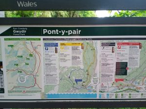
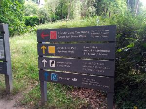
For keen walkers, Gwydir Forest Park is home to four official colour-coded routes
Which hike you opt for will come down to how long of a ramble you want and the fitness level of your walking party.
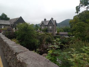
The start of all four circular trails can be found just past the Pont-y-Pair pair bridge in the centre of Betws-y-Coed.
| Trail Name | Route Colour | Distance | Approx. Time | Difficulty |
| Coed Tan Dinas Trail – Llwybr Coed Tan Dinas | Red | 0.5 miles (0.6 km) | 30 minutes | Easy |
| Cyrau Trail – Llybr Cyrau | White | 1.5 miles (2.4 km) | 1 hour 30 minutes | Medium |
| Llyn Parc Trail – Llwyber Llyn Parc | Yellow | 6 miles (10 km) | 3-5 hours | Hard |
| Pen yr Allt Trail – Llwybr Pen yr Allt | Blue | 4.3 miles (7 km) | 2-3 hours | Hard |
Gwydir Forest Park Map
Gwydir Forest Park Walks
Llwybr Coed Tan Dinas (Coed Tan Dinas Walk) – Red Route
A short stroll through the impressively tall trees which populate the forest. Simply follow the flat boardwalk path beside the river to the picnic site. For those wanting to extend the ramble slightly, from here there’s also the option to incorporate the ‘Woodland Loop’. With plenty of spots to rest or stop for a picnic break, this is an especially great trail for families.
Llwybr Llyn Parc (Llyn Parc Walk) – Yellow Route
The longest trail of the four, Llyn Parc Walk consists of forest paths and hilly terrain which will certainly get those legs burning! Providing ramblers with gorgeous lakeside views and a handful of seating benches along the way for brief respites, this trail is best for those who want to truly get the most out of their time in Gwydir Forest Park.
Llybr Cyrau (Cyrau Trail) – White Route
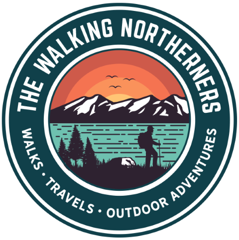
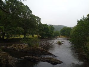
A narrow and rocky trail through the forestry, this route is a solid choice for those wanting a short yet adventurous hike in Gwydir. The views of Betws-y-Coed along the way are simply stunning. There are no benches on this route and the terrain can be quite steep in sections with numerous cliff edges, so be sure to proceed with caution!
Llwybr Pen yr Allt (Pen yr Alt Trail) – Blue Route
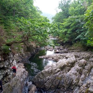
Concluding with a fantastic ramble along the River Llugwy, this route certainly has plenty of variety! Starting along the same hilly trail as the yellow route, the blue route veers off beside the lake and takes you along forest paths, through various stiles, past old derelict barns and beside dramatic riverside views. Somewhat challenging but undeniably worth the effort!
Which route do we recommend?
During our last ramble here, we decided to head out on the blue trail. Coming in at just 7-kilometre, the hike was a tranquil and challenging one without being TOO taxing.
We were spending the whole weekend in Snowdonia on a camping trip and came to Gwydir early morning. We had lots planned for the day so didn’t want to tire ourselves too much! Otherwise we most likely would have tackled the 10-kilometre yellow trail.
The walk took us through some gorgeous & quieter sections of the forest (the steep inclines will be enough to put most visitors off!) and provided us with absolutely amazing views of the surrounding mountainous landscape. 100% would recommend.
Where do you park for Gwydir Forest Park?
For those tackling any one of the four walking trails, simply finding a parking spot in Betws-y-Coed will be your best bet.
The starting points for all the routes are the same and can be found just next the Pont-y-Pair bridge in the heart of town.
Just opposite the bridge you’ll find the Pont-y-Pair Car Park. Parking spots can fill up quickly during peak periods however so alternatively you may need to park on one of several other car parks in town.
Pont-y-Pair Car Park Address: 0LS, Betws-y-Coed LL24 0BA
Diverted paths at Gwydir Forest Park
Occasionally during a trek here you may come across diverted trails. This is usually due to maintenance work or forest operations.
Sometimes trails can also be closed during extreme weather. For your safety, it’s always important to follow the diversions and not venture along a closed trail.
More Snowdonia resources
Looking for more inspiration during your time in Snowdonia National Park? Then be sure to check out our ‘12 Unmissable Things To Do In Snowdonia’ blog post. I’m positive there’s something that’ll take your eye!
Likewise, why not head over to the Wales section of the blog to read about more of our outdoor adventures in the area?
Happy walking 🚶🚶