Would you hike two days for a pint?
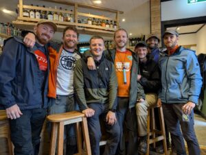
Well, that’s exactly what me and six trusty pals set out to do this past July.
Our destination? The Old Forge in Inverie, Scotland.
From the outset, safe to say this trail isn’t for the faint of heart. Knee-deep bogs, rickety bridges, river crossings and punishing inclines are but some of the obstacles hikers need to contend with.
And don’t forget the heavy load strapped to your back throughout!
For those willing to heed the call to adventure however, it’ll be the most rewarding pint you’ll ever have the pleasure of tasting.
Whether you’re planning to embark on this trail, or simply interested to hear about our experience, this post will detail everything we learned from our expedition.
Where is The Old Forge Pub?
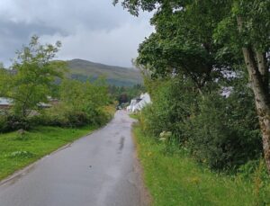
The Old Forge is nestled on the coast of the Knoydart Peninsula, in the wee village of Inverie.
Amassing worldwide acclaim, each year the pub attracts thousands of visitors for its incredibly picturesque and isolated location.
The Old Forge Walk Route Options
There are two hiking options for those wanting to walk to Inverie:
- 15-mile trail from Kinloch Hourn
- 30-mile trail from Glenfinnan
Once you arrive at Inverie, there are then multiple ferries throughout the day that can take you to the port of Mallaig.
While the 15-mile hike is less overall distance, we found it was much trickier to sort logistically. This is because the starting point – Kinloch Horn – is a tiny settlement only reachable by car along 22 miles of remote, single-track road.
While you could technically drive and park at Kinloch Horn, you’d then need to figure out how to collect your car after finishing the hike.
Some hikers do opt to walk back to Kinloch after reaching The Old Forge, which would solve the problem. But for those only walking one way, you’d likely have to undergo an expensive taxi after your excursion.
To lessen the stress of transportation and keen to hike over a longer distance anyway, we opted for the 30-mile route from Glenfinnan.
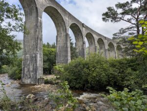
Parking the car directly in Mallaig, there are numerous trains and buses running throughout the day that’ll take you directly to the hiking start point at Glenfinnan Viaduct.
Inverie to Glenfinnan Walk Information
📍 Starting Location: Glenfinnan Viaduct
🥾 Distance: 30 miles (one way)
💪 Difficulty: Very Hard
⛅ Weather: BBC Weather, Knoydart Peninsula
Due to the Highland’s volatile weather and underfoot conditions, it’s difficult to give an exact step-by-step guide like I usually do on this blog.
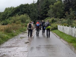
The unrelenting bogs and lack of footpaths means that while everybody heads in the same general direction, folks tend to improvise their own way across open sections given how things are looking on the day. We bumped into several hiking groups en route, each carving their own way through the sloppy Scottish terrain.
Nevertheless, to ensure you keep on track, downloading an app such as AllTrails or OS Maps beforehand is a must. We took a few wrong turns along the way, though frequently tracking our GPS ensured we never veered too far afield.
Likewise, while I can’t accurately detail every step of this excursion, a journal of our experience should still provide some helpful information and (hopefully) some entertainment.
Let’s get to it 👇
The Old Forge Walk Journal – Glenfinnan to Inverie
Day 1 – Glenfinnan to A’Chuil bothy
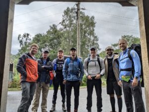
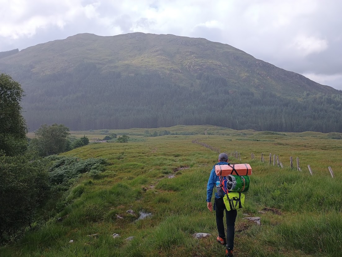
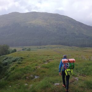
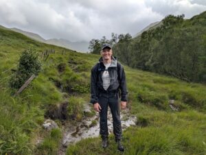
Landing in Mallaig just before midday, we boarded the 12:10 bus to Glenfinnan, eager to get underway. Arriving at the Viaduct just before 1:30pm, we readied our packs, took a quick group picture and set along the trail.
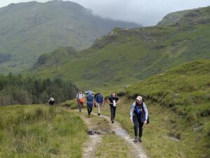
The first few miles of the route were mostly flat, though we quickly appreciated how much a heavy pack can weigh you down. Several of us confided that we were already feeling some shoulder discomfort from the weighty load, though the majestic surroundings were a welcome distraction.
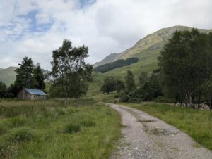
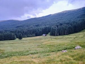
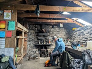
The footpath was well laid out as we approached the first bothy. After a quick nosey inside, we continued along the track until we crossed a bridge and cast our eyes upon first major incline of the trek.
Marching up into the clouds, the rocky trail soon faded until boggy footprints and trodden tall-grass were all that guided the way.
With our legs still fresh so early into the trek, we scaled the hill relatively easily which kept spirits high.
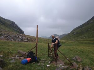
Taking a 10-minute respite by the isolated gate at the summit, we refueled on snacks before trudging ahead.
We were making good time, though blissfully unaware how long and time-consuming the next section would prove to be.
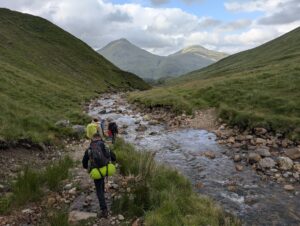
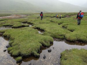
Dropping down the other side of the hill and following the river towards the woodlands in the far distance, we were hit with arguably the most draining part of the whole trip. While reasonably flat, the bog just didn’t let up. In fact, the further along we got, the Highland slop only seemed to get deeper and more frequent.
To avoid a particularly marshy section, at one point we veered up the hillside to our left, which helped for a short while until we needed to head back down and cross the river. The descent was dangerously steep since we’d climbed too high up, and as we began to realise the mistake we’d made, one of my pals tripped and came alarmingly close to toppling down the hill face.
Eventually finding a safe(ish) route down to the stream, we were pleased to see that the crossing was rather shallow. This meant we could hop along the scattered rocks in our walking boots without the faff of changing into our river shoes.
Plodding on, we were all starting to feel somewhat fatigued by this point. While the terrain was never super technical, the swampland is a real morale sapper and slows your every step. Several of us slipped or had our legs swallowed by hidden boggy holes in the wetlands beyond the river crossing.
I admittedly did. Several times.
Nevertheless, as evening loomed, we finally cast eyes on the next segment of the hike; a woodland entrance a few hundred metres ahead. Even better, we could also spot a dry footpath, filling us all with relief.
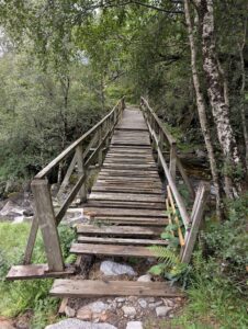
Before stepping onto the trail however, we first had a risky bridge crossing to contend with. As we approached, we noticed some of the beams had already rotten away, and others looked to be in no condition to hold our weight.
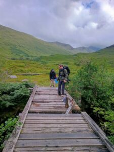
As each of us meticulously crossed the bridge beam-by-beam, our sense of accomplishment was immediately interrupted on the other side as we dropped right into a midge horde. We hurriedly threw on our head nets and scampered into the safety of the woodlands.
Despite the midges, our sodden feet were thankful to be back on dry land.
Our group was pretty fried by now, but we made a last push along the forest track since we knew A’Chuil bothy wasn’t too far away.
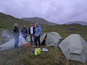
Doddering on until we finally arrived at the bothy around 20:00, it was predictably already at full capacity, so we opted to wild camp on higher ground a few hundred metres away. The wind up there helped deter the midges.

We had a relaxing night at camp, with the collective tiredness making us all rather giddy. After some well-needed food and a good laugh, we cosied up in our tents around 22:30.
That should have marked the end of our action-packed day, but turns out the Highlands still had one more curveball to throw our way…
While six of us camped together out in the open, one of our friends decided to solo camp in his hammock tent around half a kilometre away in the nearby forestry.
To our surprise, he hurriedly returned to our camp just after 11pm as we were dosing off, covered in sludge and asking for assistance.
While cooking his dinner, he’d noticed a pair of beady eyes watching him from deep in the woodlands. Initially not paying it much mind, the creature slowly stalked towards his encampment until it got uncomfortably close. Still unable to decipher what he was dealing with in the darkness of night, it then started bellowing out a barking-like noise at him.
He tried yelping back in hopes of scaring it, but the animal stood firm and wouldn’t retreat. Fearing for his safety, he abandoned his belongings and legged it back to our camp, falling into a waist high bog along the way.
Roused from our tents, we marched into the forest to retrieve his belongings. What was a seemingly desolate landscape during daylight had now turned into eerie hillsides, teeming with silhouettes of deer glaring from up high.
We hastily grabbed our friend’s gear as another member of our party kept watch with his flashlight, who managed to spot those same eyes, intently watching on from the shadows.
Thinking back on the encounter, the animal was likely a territorial deer. But as we stood there in pitch-black wilderness, rumours began circulating about wolf re-wilding projects in the region. Without any phone signal to fact check, the troubling prospect lingered on in our minds as we navigated back to camp.
It took a little while to settle down that night after all the commotion, and before we knew it, the sun was rising and day two of our journey was already underway.
Day 2 – A’Chuil bothy to Inverie
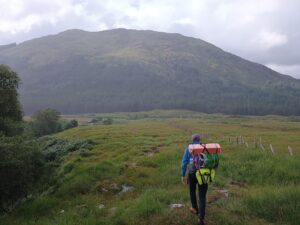
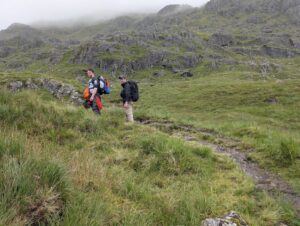
Akin to day one of our hike, we were treated to an easy-to-follow trail for the first few miles before it gradually turned into another boggy incline.
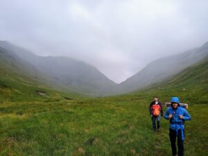
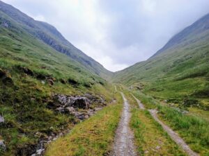
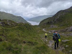
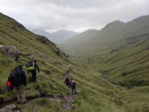
After the uphill, we followed the weaving river through striking craggy valleys for several enjoyable miles.
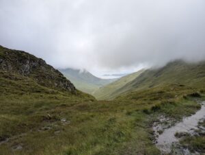
Despite the tiredness, we all couldn’t help but be awe-struck by the remote beauty of the Knoydart wilderness. We were truly in the thick of it.
With my mind distracted by the spectacular panoramas, before I knew it, the next bothy was already in sight.
Stopping for a brief food break at Sourlies bothy, alarm bells within the team did start ringing around this point. We’d fallen a few hours behind schedule, so there was growing concern whether we’d make it to Inverie in time for our pre-booked 18:30 ferry back to Mallaig – the last ride of the day.
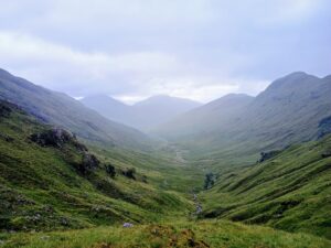
Looking on our map, the end point still seemed a fair way off. We knew we had to contend with a notoriously boggy swamp ahead, followed by a mammoth Munro climb before the long and gradual descent into Inverie.
We took a quick 20-minute break to refuel in the bothy before setting off at 12:45pm, determined to pick up the pace and avoid being deserted for the night.
Throughout our excursion, we’d been told by several walkers heading in the opposite direction that the upcoming swamp was the most difficult segment of the hike. Much to our joy however, it turned out to be nowhere near as harsh as anticipated.
Upon entering the marsh, we encountered two blokes who advised us to stick close to the river. The terrain was driest and safest beside the water, while deeper into the swamp they warned of three-metre deep bog drops.
Understandably wanting to steer clear of those, we heeded their advice. We made exceptional time hopping our way through the marshes, which energised the party with a newfound optimism.
That is until we crossed the bridge out of the swamp and were immediately faced with the final uphill. I’m unsure how difficult this incline would feel when fresh, but traipsing upwards on poor sleep and tired legs was a real mental grind to say the least.
With our heads down in silence, we all lumbered up the imposing Munro at our own pace, meaning our party soon became staggered. Towards the front of the pack, I staved off the weariness with jelly babies, spurred on by thoughts of the pub looming ever closer.
The final stretch to The Old Forge
After pushing through 550 metres of pain and eventually reaching the summit, the realisation that we still had over three hours to get to Inverie was unbelievably elating.
One of our party members decided to run the whole downhill and get it over with, while the rest of us made the final stomp towards the village.
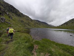
The path was well laid out for the concluding four miles. And with our feet once again treated to dry ground and powered by a second wind, we clocked the fastest pace we did the whole trip.
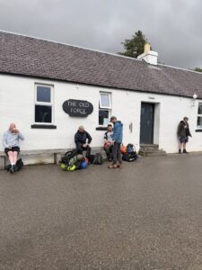
Reaching Inverie just after 5pm, walking along that lochside stretch as the pub slowly came into view was a thing of beauty.
Delighted to cross the finish line – and relieved that we weren’t stranded for the night – we ordered our drinks and took a well-deserved sit down.
Despite the aches and pains that were becoming more noticeable as the adrenaline wore off, our minds were riding high.
There’s something curiously cathartic about thru hiking. Venturing deep into the solitude of nature, far removed from the comforts and bustle of modern living. Almost like a pilgrimage, I find it does my soul the world of good.
I’m sure my friends would agree.
After an hour of soaking up the atmosphere at The Old Forge, it was sadly time to say goodbye and hop aboard the ferry to Mallaig. Having been stationary for most of that time however, we came to find that our bodies had seized up and weren’t for budging!
Hobbling to the boat, battered but victorious, we sailed back to civilisation where we looked forward to hot food and a cosy bed for the night.
The Old Forge Hike – FAQs
How long does the Glenfinnan to Inverie walk take?
Most hikers enjoy this walk over three days, staying at A’Chuil bothy on day one, Sourilles bothy on day two and finishing in Inverie on day three.
For walkers wanting to complete the trail in a shorter duration (as we did), it is possible to slog it out over two days if your party is in decent hiking shape. We had to cram the expedition into just 1.5 days, which made it considerably more taxing than if it was spread over a longer duration.
I’ve even read of hardcore hikers completing this trail in under 24 hours. While technically doable, this takes some serious fitness and success would be heavily dependent on hiking conditions on the day.
How do I catch the ferry from Inverie?
You can pre-book your ferry on the official website here.
Inverie can get busy with tourists during peak periods, so it’s definitely worth pre-booking to ensure a spot.
Where can I park my car in Mallaig?
East Bay Car Park in Mallaig is sizeable and offers free overnight parking. We had no trouble finding spots here, though you’re not able to pre-book so spaces can’t be guaranteed.
Where to stay?
There are plenty of accommodation options in Mallaig. We opted for the Westhighland Hotel, which I’d certainly recommend. It’s only a stone’s throw from the ferry terminal, and the restaurant offered a great selection of food to refuel post-hike.
Alternatively, there are a handful of places to stay overnight in Inverie. This’d be your best bet if you wanted to spend longer at The Old Forge, though I’d advise booking well in advance to secure a spot.
If you don’t mind roughing it however, you could always just wild camp another night!
Best time of year to do the Old Forge hike?
Most hikers tend to tackle the trail to Inverie anytime from May – September. Hiking outside of these months means you’ll be faced with less daylight, more hazardous terrain and harsher weather.
The conditions weren’t great when we completed the walk in July, so I dread to think what they’d be like out of peak season.
What to pack for the Old Forge hike?
It’s of utmost importance to pack the right gear for a multi-day trek, especially one such as The Old Forge hike which involves navigating unpredictable Highlands terrain. Detailing everything you need to consider would require writing a whole new article, much too much information to cram on the end of this post unfortunately.
I’d personally suggest checking out Matt Walk Wild’s ‘Multi-Day Hike Kit List’ as a solid overview of what to keep in mind.
Nevertheless, if there’s one thing I’d like to stress, it’s the importance of having good quality walking boots and walking socks.
One member of our party didn’t heed this advice, and his feet were an absolute blistery mess for weeks after the hike.
I’ll spare you the imagery, but I will include a link to my ‘BEST Walking Socks: 5 Brands Built For Hikers’ post to help anybody who’d like some recommendations.
More resources
For more walking inspiration, why not trawl through more of the site?
If walking challenges are your thing, I’d start with:
- 11 Of The Best UK Walking Challenges For Daring Hikers
- Tips For Tackling The National 3 Peaks Challenge
- The Yorkshire 3 Peaks Challenge Guide
- 10 Of The Best Hiking Snacks To Fuel Your Next Adventure
Happy walking 🚶🚶