

Just outside of Greater Manchester’s borders, hiding on the hills above Glossop, lies the eerie remains of an old aircraft crash site known as the ‘Bleaklow Bomber’.
While the Peak District is famed for its wide array of outdoor wonders to discover, many locals & visitors are completely unaware that it’s also home to this chilling historical site.
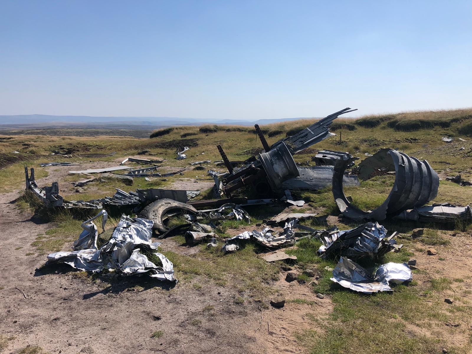
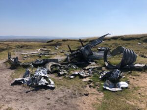
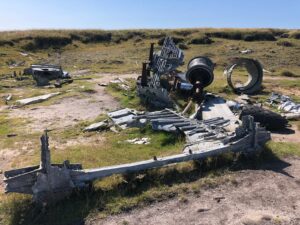
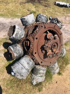
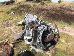
The US Air Force craft (nicknamed ‘Over Exposed’) crashed here in 1948, with much of the plane wreckage still remaining scattered on the Bleaklow moors today along with a touching memorial plaque.
What is the ‘Bleaklow Bomber’?
The Bleaklow Bomber plane was a B-29 Superfortess, renowned as one of the largest aircraft models in operation during the Second World War.
While B-29 planes were typically built for high altitude-bombing (hence the name Bleaklow ‘Bomber’), this aircraft was modified as a reconnaissance aircraft and specifically used for photographic assignments.
The Bleaklow Bomber was nicknamed ‘Over Exposed’ during 1946 when tasked with the important mission of photographing the US nuclear testing operation in the Marshall Islands.
Codenamed Operation Crossroads, the mission was designed to investigate the effect that nuclear weaponry had on warships. This nuclear testing was extremely important for the time as it marked the first nuclear detonation since the atomic bombing of Nagasaki in August 1945.
How did the B-29 ‘OVEREXPOSED’ crash?
The aircraft dubbed ‘Over Exposed’ fell from the sky on 3rd November 1948, crashing on the Bleaklow moorlands near Glossop during a routine flight from RAF Scrampton in Lincoln to the US Base just outside of Warrington.

While B-29 engines developed a reputation for being prone to fires and failure after the aerial bombing campaign over Japan in 1944-1945, malfunction was not the cause of the crash on Bleaklow moor.
Instead, the aircraft’s vision was obscured by heavy cloud. Basing their location on flight time alone, the crew estimated they’d already flown past the hills and decided to descend.
Hitting the ground at approximately 11:00am, the B-29 carrier burst into flames, tragically taking the lives of all 11 crew and 2 military passengers.
Where is the Bleaklow Bomber plane crash site?
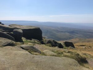
While there are several ways to get to the crash site, the easiest is via the Snake Pass walk.
The Snake Pass can be found in the Peak District, along the A57 main road that runs from Ladybower Reservoir to Glossop.
Following the Snake Pass, the hike up to the plane wreckage is around 2 miles (3.2km). Simply stay on the trail up the hillside, following signposts for the crash site.
In memory of the Bleaklow Bomber
Once you reach the top of the hill and arrive at the scene, the atmosphere suddenly turns very quiet.
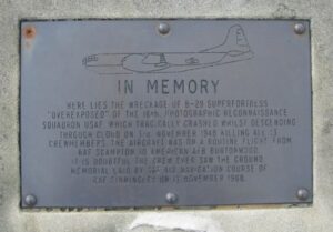
The wreckage of the aircraft radiates a strong sense of remembrance and contemplation. Paying our respects, the touching memorial plaque at the site reads:
“Here lies the wreckage of B-29 Superfortress ‘Over Exposed’ of the 16th. Photographic reconnaissance squadron USAF. Which tragically crashed whilst descending through cloud on 3rd November 1948 killing all 13 crewmembers. The aircraft was on a routine flight from RAF Scampton to American AFB Burtonwood. It is doubtful the crew ever saw the ground. Memorial laid by 367 Air Navigation Course of RAF Finningley on November 12th 1988.”
Top tip: If you decide to lengthen your ramble, it’s also worth checking out the higher and lower ‘shelf stones’, which are just a short walk further up the hill from the Bleaklow Bomber crash site.
Where do I park for the Bleaklow plane crash?
Parking along the free lay-by near Pennine Way on the A57 at the start of the Snake Pass would be your best bet, but you’ll want to get here early since it can fill rather quickly during peak times.
The postcode for this parking spot is SK13 7PQ.
How difficult is the walk to the Bleaklow plane crash site?
The Snake Pass is easy to follow and well-maintained, so heading up and down this way should be straight forward enough for most.
On our last visit we continued along one of the various connecting trails however, improvising a circular route that ended up proving trickier (and boggier) than anticipated.
Luckily we were blessed with a sunny day; walking in less favourable weather would have made it considerably more difficult.
Local mountain rescue teams have issued warnings when visiting during winter months since they’ve previously had to help ill-prepared walkers.
Standing at 633 metres, Bleaklow Head is the second highest point in Derbyshire. The weather can change in an instant at these altitudes. It’s essential to pack the correct clothing and to know where you’re going.
Patch Haley, team leader of Glossop Mountain Rescue stresses that winter walkers “bring food, water, a torch, and a map and compass. And be confident you can use them.”
For information on weather before your visit, be sure to check out the Snake Pass BBC forecast here.
More Bleaklow Bomber Crash Site walk routes
While what I’ve detailed above is the most direct way to access the Bleaklow Bomber Crash Site, there are also several alternate walking options well worth a shout out.
For experienced hikers really wanting to make a full day of their visit, then why not try this 11-mile circular trail starting from Old Glossop?
Old Glossop and Bleaklow Head Circular
A challenging yet rewarding ramble taking in much of the local scenery, along this trail you’ll encounter the Higher Shelf Stones and James’s Thorn before arriving at the Bleaklow crash site. From there, you’ll continue ahead, making the descent back to Old Glossop via Cock Hill.
Treating hikers to a variety of gorgeous panoramas throughout and bound to get those legs burning, finishing up in Old Glossop also means you’ll have the chance to refuel in town with a well-deserved pint and some grub afterwards!
More Resources
Interested in more outdoor adventures around the Peak District? Then be sure to check out our comprehensive guide for the notorious Jacob’s Ladder Kinder Scout climb; officially the highest point in the National Park.
Happy walking 🚶🚶